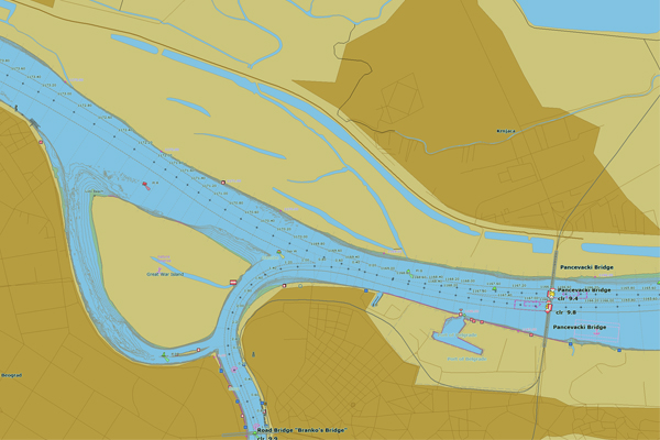
Date: /
Last update: /
Srpski jezik
English language
français
deutch


Daily Water Levels and Hydrological Forecast (cm)

River Gauging station H Δ trend 24h 48h 72h 96h LNL HNL T (°C) Ice rkm
DUNAV Bezdan


-10 602


Apatin


47 674


Bogojevo


11 596


Bačka Palanka


47 578


Novi Sad


57 573


Slankamen


117 623


Zemun


213 632


Pancevo


252 622


Smederevo


439 680


Banatska Palanka


Veliko Gradište


Prahovo


576


SAVA Jamena


Sremska Mitrovica


37 622


Šabac


-64 478


Beograd


162 560


TISA Novi Kneževac


149 617


Senta


217 630


Novi Bečej


283 718


Titel


129 646


Source: 
Republički hidrometeorološki zavod Srbije, za više informacija posetite www.hidmet.gov.rs

Wind data
River Station Wind speed
(m/s)
Wind direction Weather description
Danube Sombor


Novi Sad


V. Gradište


Beograd


Sava S. Mitrovica


Source:
Republic Hydrometeorological Service of Serbia,
for more information www.hidmet.gov.rs

Active Notices to Skippers
River Source Valid from Valid until Subject Content
/ / / / / ...
Source: RIS Serbia - Notices to Skippers

Waterway marking plan
DanubeAnnual marking system regime
Sava Annual marking system regime
Tisza Winter marking system regime
Current status of the marking system
Marking signs
Source: Directorate for Inland Waterways


Available Fairway Depths and Widths at Critical Sectors
River Critical sector From
km
To
km
min.
depth
(dm)
max.
depth
(dm)
Available
width
(m)
Date of survey Layout
Remark
Danube
Bezdan 1429.0 1425.0 / / / / / /
Siga-Kazuk 1424.2 1414.4 / / / / / /
Apatin 1408.2 1400.0 / / / / / /
Civutski rukavac 1397.2 1389.0 / / / / / /
Drava confluence 1388.8 1382.0 / / / / / /
Aljmas 1381.4 1378.2 / / / / / /
Staklar 1376.8 1373.4 / / / / / /
Erdut 1371.4 1366.4 / / / / / /
Bogojevo 1366.2 1361.4 / / / / / /
Dalj 1357.0 1351.0 / / / / / /
Borovo 1 1348.6 1343.6 / / / / / /
Borovo 2 1340.6 1338.0 / / / / / /
Vukovar 1332.0 1325.0 / / / / / /
Sotin 1324.0 1320.0 / / / / / /
Opatovac 1315.4 1314.6 / / / / / /
Mohovo 1311.4 1307.6 / / / / / /
B.Palanka-Ilok 1302.0 1300.0 / / / / / /
Susek 1287.0 1281.0 / / / / / /
Futog 1267.4 1261.6 / / / / / /
Novi Sad 1255.4 1254.2 / / / / / /
Arankina Ada 1247.0 1244.8 / / / / / /
Cortanovci 1241.6 1235.0 / / / / /
/
Beska 1232.0 1226.6 / / / / /
Preliv 1207.0 1195.0 / / // / /
Sava Drina confluence 184.0 177.0 / / / / /
/
Sremska Mitrovica 134.0 126.8 / / / / /
/
Klenak 112.6 106.0 / / / / /
/
Sabac 104.0 90.0 / / / / /
/
Kamicak 88.2 82.2 / / / / /
/
Layout guide 
Source: Directorate for Inland Waterways

DISCLAIMER (Terms of Use):

Depth data at critical sectors are informational, based on actual water levels and results of the latest hydrographic surveys. Data on available vertical clearances at navigational openings at bridges are informational, based on actual water levels. Directorate for Inland Waterways calculates and publishes these data in a best manner, as an aid to all users of waterways. All actual dynamic data at the Navigational Bulletin are temporary and subject to a change. Errors in calculations are not likely, but are possible. Directorate for Inland Waterways carries no liability and cannot be held responsible for any damage resulting from a use of these data. Directorate for Inland Waterways strongly advises careful consideration of all data published at the Navigational Bulletin before their usage.

Critical sectors – Forecast of minimum and maximum available depths (dm)
River Critical sector From
km
To
km
24h 48h 72h 96h
min max min max min max min max
Danube Bezdan 1429.0 1425.0


Siga-Kazuk 1424.2 1414.4


Apatin 1408.2 1400.0


Civutski r. 1397.2 1389.0


Drava confluence 1388.8 1382.0


Aljmas 1381.4 1378.2


Staklar 1376.8 1373.4


Erdut 1371.4 1366.4


Bogojevo 1366.2 1361.4


Dalj 1357.0 1351.0


Borovo 1 1348.6 1343.6


Borovo 2 1340.6 1338.0


Vukovar 1332.0 1325.0


Sotin 1324.0 1320.0


Opatovac 1315.4 1314.6


Mohovo 1311.4 1307.6


B.Palanka-Ilok 1302.0 1300.0


Susek 1287.0 1281.0


Futog 1267.4 1261.6


Novi Sad 1255.4 1254.2


Arankina Ada 1247.0 1244.8


Cortanovci 1241.6 1235.0


Beska 1232.0 1226.6


Preliv 1207.0 1195.0


Sava Drina confluence 184.0 177.0


Sremska Mitrovica 132.4 126.8


Klenak 112.0 106.0


Sabac 104.0 90.0


Kamicak 88.2 82.2


Source: Directorate for Inland Waterways
Data on forecast of available depths at critical sectors are being published for those critical sectors for which reference gauging stations provide forecast of water levels

Bridges - Available Vertical Clearances
River Bridge Minimum
vertical
clearance
(m)
Maximum
vertical
clearance (m)
Width of the navigational opening
(m)
Chainage
(km)
Danube Drumski most Bezdan

120 1424.42
Drumski most Bogojevo

125 1366.62
Železnički most Bogojevo

80 1366.44
Drumski most Bačka Palanka

120 1297.05
Drumski most „Sloboda” Novi Sad

190 1257.57
Drumski most „Varadinska Duga” Novi Sad

125 1255.07
„Žeželjev most" Novi Sad

150 1254.20
Drumski most Beška

180 1232.16
„Pupinov most” Beograd

150 1176.10
Drumsko-železnički most Pančevo

145 1166.62
Most „Gasovod - Smederevo”

120 1113.00
Drumski most Smederevo

150 1112.20
SavaDrumsko-železnički most „Rača”

140 183.31
Pešački most Sremska Mitrovica

100 139.24
Drumski most Sremska Mitrovica

150 136.60
Železnički most Šabac

75 106.96
Drumski most Šabac

80 104.53
Drumsko-toplovodni most Obrenovac

80/120 42.53
Železnički most Ostružnica

75/75 15.43
Drumski most Ostružnica

150 15.00
Most na Adi

150 3.80
Novi železnički most Beograd

120 3.00
Stari železnički most Beograd

90 2.73
Drumski most „Gazela” Beograd

200 2.52
Drumsko-tramvajski most Beograd

90 1.43
Drumski most „Brankov most” Beograd

100 1.00
Source: Directorate for Inland Waterways

Bridges – Forecast of minimum available vertical clearances of navigation openings (m)
River Bridge 24h 48h 72h
96h Chainage
(km)
Danube Drumski most Bezdan


1424.42
Drumski most Bogojevo


1366.62
Železnički most Bogojevo


1366.44
Drumski most Bačka Palanka


1297.05
Drumski most „Sloboda” Novi Sad


1257.57
Drumski most „Varadinska Duga” Novi Sad


1255.07
„Žeželjev most" Novi Sad


1254.20
Drumski most Beška


1232.16
„Pupinov most” Beograd


1176.10
Drumsko-železnički most Pančevo


1166.62
Most „Gasovod - Smederevo”


1113.00
Drumski most Smederevo


1112.20
SavaDrumsko-železnički most „Rača”


183.31
Pešački most Sremska Mitrovica


139.24
Drumski most Sremska Mitrovica


136.60
Železnički most Šabac


106.96
Drumski most Šabac


104.53
Drumsko-toplovodni most Obrenovac


42.53
Železnički most Ostružnica


15.43
Drumski most Ostružnica


15.00
Most na Adi


3.80
Novi železnički most Beograd


3.00
Stari železnički most Beograd


2.73
Drumski most „Gazela” Beograd


2.52
Drumsko-tramvajski most Beograd


1.43
Drumski most „Brankov most” Beograd


1.00
Source: Directorate for Inland Waterways
Data on forecast of available vertical clearances at bridges are being published for those bridges for which reference gauging stations provide forecast of water levels

Available depths at berths
River Berth Minimum depth at the anchoring zone (dm) Purpose Bank
From km To km Layout Extract from the Atlas of berths
Danube Kamenjar - General purpose left 1260.70 1259.60 - -
Arankina Ada - Special purpose left 1247.60
1247.00
- -
Karaburma - General purpose right 1166.40 1165.80 - Izvod
Krnjača - Special purpose left 1163.40
1163.00
- Izvod
SavaS. Mitrovica - General purpose right 134.81 134.40 - Izvod
S. Mitrovica - Special purpose right 134.35 134.00 - Izvod
Boljevci - Special purpose right 19.64 19.30 - Izvod
Ostružnica - General purpose left 16.50 16.20 - Izvod
Source: Directorate for Inland Waterways

Forecast of available depths at berths
River Berth 24h 48h 72h 96h From km To km
Danube Kamenjar - - - - 1260.70
1259.60
Arankina Ada - - - - 1247.60 1247.0
Karaburma - - - - 1166.40
1165.80
Krnjača - - - - 1163.40 1163.00
SavaS. Mitrovica - - - - 134.81 134.40
S. Mitrovica - - - - 134.35 134.00
Boljevci - - - - 19.64 19.30
Ostružnica - - - - 16.50 16.20
Source: Directorate for Inland Waterways

Availability of Locks
River Lock SRB ROM

Status

Status

Danube Ðerdap I
-

Danube Ðerdap II
-
-
Tisza Tisza Lock
- n/a n/a
Legend
Available for upstream and downstream navigation
Available for upstream navigation
Available for downstream navigation

Not available
The lock is not operational within the specified time period

Information unavailable
Source: HE Đerdap Vode Vojvodine

Availability of RIS (River Information Services)
Type of RIS service status pristupi servisu
Vessels Tracking and Tracing (VTT)
Notices to Skippers (NtS) nts.plovput.rs
Electronic Navigational Charts (ENC)Preuzmite elektronske plovidbene karte
Electronic Reporting International (ERI) eridgw.risserbia.rs
Legend
Available
Partially available
Not available
Information unavailable
Source: Directorate for Inland Waterways

Contacts
Harbour Master
Bezdan
Carinska kolonija bb,
Bezdan
+381 25 819 958  lk.bezdan [at] mgsi.gov.rs
Harbou Master Apatin Dunavske obale bb,
Apatin
+381 25 772 245 ispostava.apatin [at] mgsi.gov.rs
Harbour Master Novi Sad Beogradski kej 11,
Novi Sad
+381 21 526 684 lk.nsad [at] mgsi.gov.rs
Harbour Master  Beograd Karađorđeva 6,
Beograd
+381 11 202 9906 lk.beograd [at] mgsi.gov.rs
Harbour Master Pančevo Dositeja Obradovića 13,
Pančevo
+381 13 342 560 ispostava.pancevo [at] mgsi.gov.rs
Harbour Master Smederevo Despota Đurđa 11,
Smederevo
+381 26 227 140 lk.smederevo [at] mgsi.gov.rs
Harbour Master Veliko Gradište Obala Kralja Petra I 13,
Veliko Gradište
+381 12 662 219 lk.vgradiste [at] mgsi.gov.rs
Harbour Master Kladovo Dunavska 11,
Kladovo
+381 19 800 284 ispostava.kladovo [at] mgsi.gov.rs
Harbour Master Prahovo Pristanišna zona bb,
Prahovo
+381 19 3524 026 lk.prahovo [at] mgsi.gov.rs
Harbour Master S. Mitrovica Promenada 13,
Sremska Mitrovica
+381 22 621080 lk.smitrovica [at] mgsi.gov.rs
Harbour Master Senta Tiski cvet 6,
Senta
+381 24 812 200 lk.senta [at] mgsi.gov.rs
Harbour Master Titel Potiski kej 1,
Titel
+381 21 862 133 ispostava.titel [at] mgsi.gov.rs
Navigation Lock
Iron Gate I
/ +381 19 811 390 /
Navigation Lock
Iron Gate II
/ +381 19 546 242 /
Authority for Determination of the Seaworthiness Narodnih heroja 30,
Beograd
+381 11 260 70 80 office [at] uprava-brodova.gov.rs
Port Governance Agency Nemanjina 22-26,
Beograd
+381 11 311 20 08 office [at] aul.gov.rs
Republic Hydrometeorological Service of Serbia Kneza Višeslava 66,
Beograd
+381 11 30 50 923 office [at] hidmet.gov.rs
Authority for the Transport of Dangerous Goods Omladinskih brigada 1,
Beograd
+381 11 3122 780 / 3122 781 office [at] utot.gov.rs

We would like to thank the Republic Hydrometeorological Service of Serbia and the HENS Iron Gate on cooperation and provision of information relevant for navigation.
Without them, publication of the Navigational Bulleting in this form would not be possible.


RSSPlovput FacebookPlovput TwitterPlovput InstagramPlovput Youtube


download documents

Informer

Photo Gallery

newsletter


Stakeholders' Forum

Danube Glossary 2019


Danube Stream